Answer: VERO
Information Signs — Practice Question 161
Official exam text (Italian):
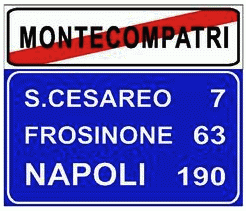
Il segnale raffigurato indica la fine del centro abitato e le località successive

Study the whole theory course in the Driving Freedom app
Bilingual audio lessons that teach the rules behind the questions, not just the answers.
Driving Freedom gives you 6,700+ Patente B exam practice questions, with explanations in English, Persian and Arabic. Download the app and start today.


Read this in another language:
Information Signs — Practice Question 161
The sign shown indicates the end of the built-up area and subsequent localities.
علائم اطلاعاتی — سوال تمرینی شماره 161
صحیح: «این علامت نشاندهنده پایان منطقه مسکونی و مکانهای بعدی است.»
إشارات إرشادية — سؤال تدريبي رقم 161
تشير العلامة الموضحة إلى نهاية المركز السكاني والمناطق التالية.
Segnali di indicazione — Domanda di pratica 161
Il segnale raffigurato indica la fine del centro abitato e le località successive
Related questions
VERO Il segnale raffigurato indica la fine del centro abitato VERO Il segnale raffigurato nella prima riga in alto del pannello blu indica il prossimo centro abitato VERO Il segnale raffigurato nel pannello blu indica, per ogni località, la rispettiva distanza chilometrica VERO Il segnale raffigurato indica che per Napoli mancano 190 chilometri VERO Il segnale raffigurato indica che per S. Cesareo mancano 7 chilometri FALSO Il segnale raffigurato indica l'inizio di un tratto di strada in salita per raggiungere Montecompatri FALSO Il segnale raffigurato indica che non è possibile raggiungere Montecompatri FALSO Il segnale raffigurato indica che per raggiungere Napoli bisogna percorrere la strada statale n. 190
See all questions in Fine centro abitato →